Maps, atlases, cartographic reference material and other map-related items are currently acquired in four ways:
- By legal deposit — material published in the UK
- By purchase — antiquarian maps (printed and manuscript) and modern foreign published material
- By donation — if you wish to donate an item, see our guide for donors
- By deposit — items of national interest deposited for safekeeping; they remain the property of the owner.
We aim to collect —
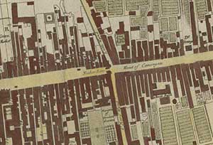
Detail from Plan of the city and
castle of Edinburgh'
by William Edgar, 1765.
castle of Edinburgh'
by William Edgar, 1765.
Maps and related material connected with Scotland:
- Maps of Scotland produced by Scottish and foreign mapmakers.
- Maps and atlases of all parts of the world produced by Scottish map producers of the past and present.
- Maps and atlases relating to all parts of the world with a Scottish association.
Worldwide mapping and related material:
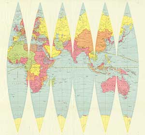
Detail from 'Globe Gores'
ca 1923.
ca 1923.
- New maps, atlases and reference works published in the United Kingdom, through the legal deposit privilege. These relate to all parts of the world.
- An extensive reference collection of foreign-published topographic and thematic maps, atlases, and reference works relating to cartography.
Depending on availability and funding, we collect maps at the following scales:- Europe: 1:50,000 or nearest available scale
- Other parts of the world: 1:200,000-1:250,000
- Larger scales are available for some countries and islands.
Forms of cartography:
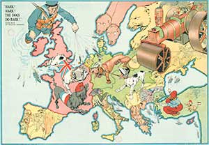
'Hark! Hark! The dogs do bark!'
war cartoon map, 1914.
war cartoon map, 1914.
- A representative collection of all major forms of cartography, including examples of map ephemera, and of types of cartographic production and expression.